BOM Radar Brisbane 128km Mt Stapylton Queensland’s Weather Eye
The Bureau of Meteorology (BOM) radar at Brisbane 128km Mt Stapylton is a critical component of Australia’s weather observation system, providing real‑time radar data for rainfall, storms, and atmospheric motion across southeastern Queensland. As one of the most important weather radars serving the Greater Brisbane region, Mt Stapylton helps meteorologists, emergency services, and residents track precipitation intensity and storm movement with precision.
Australia’s weather patterns are highly dynamic, with tropical systems, thunderstorms, and seasonal weather fronts all influencing local conditions. The Mt Stapylton radar plays a major role in detecting and monitoring these changes, allowing forecasts and warnings to be delivered promptly and accurately to communities across the state.
The 128km radar is part of a broader national radar network, which together provides comprehensive coverage of real‑time rainfall and wind conditions. This network supports critical decision‑making for flood response, disaster preparedness, aviation safety, and daily weather forecasting.
In this guide, we’ll explore how the 128km BOM radar at Brisbane Mt Stapylton works, its coverage and technology, how to interpret radar data, how it aids local weather forecasting, and key questions about its operation and applications.
BOM Radar Brisbane 128km Mt Stapylton: The Complete Guide to Queensland’s Weather Eye
What Is the BOM Radar at Brisbane 128km Mt Stapylton?
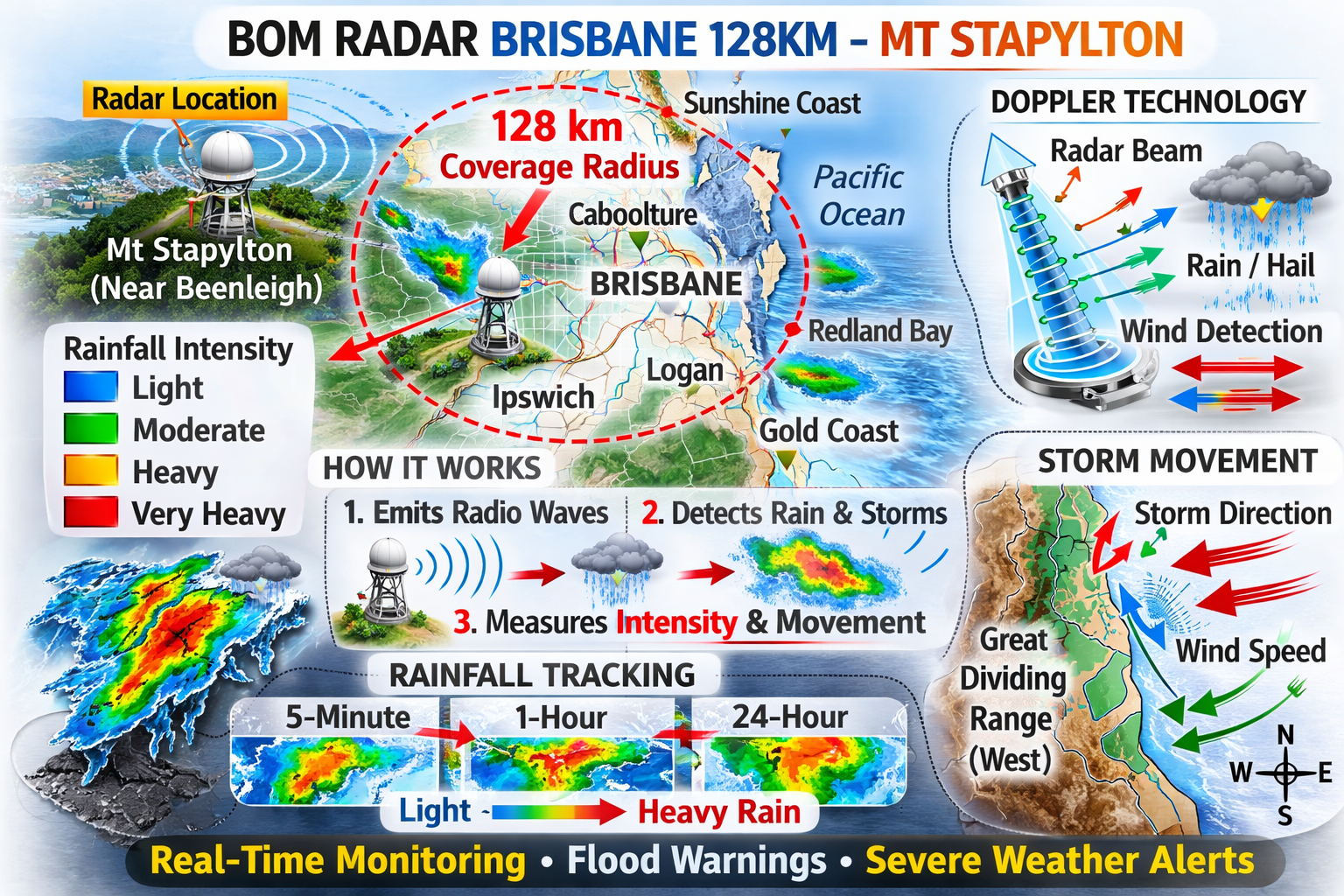
The BOM radar at Brisbane Mt Stapylton is a Meteor 1500 S‑band Doppler weather radar that provides continuous observation of rainfall and wind data over a wide area of southeastern Queensland.
It is strategically sited on an isolated hill approximately 150 metres above sea level just east of Beenleigh, offering optimal coverage of the Brisbane Valley and surrounding regions. This location was chosen because its elevation provides excellent low‑level radar visibility across the metropolitan area and adjacent hinterland.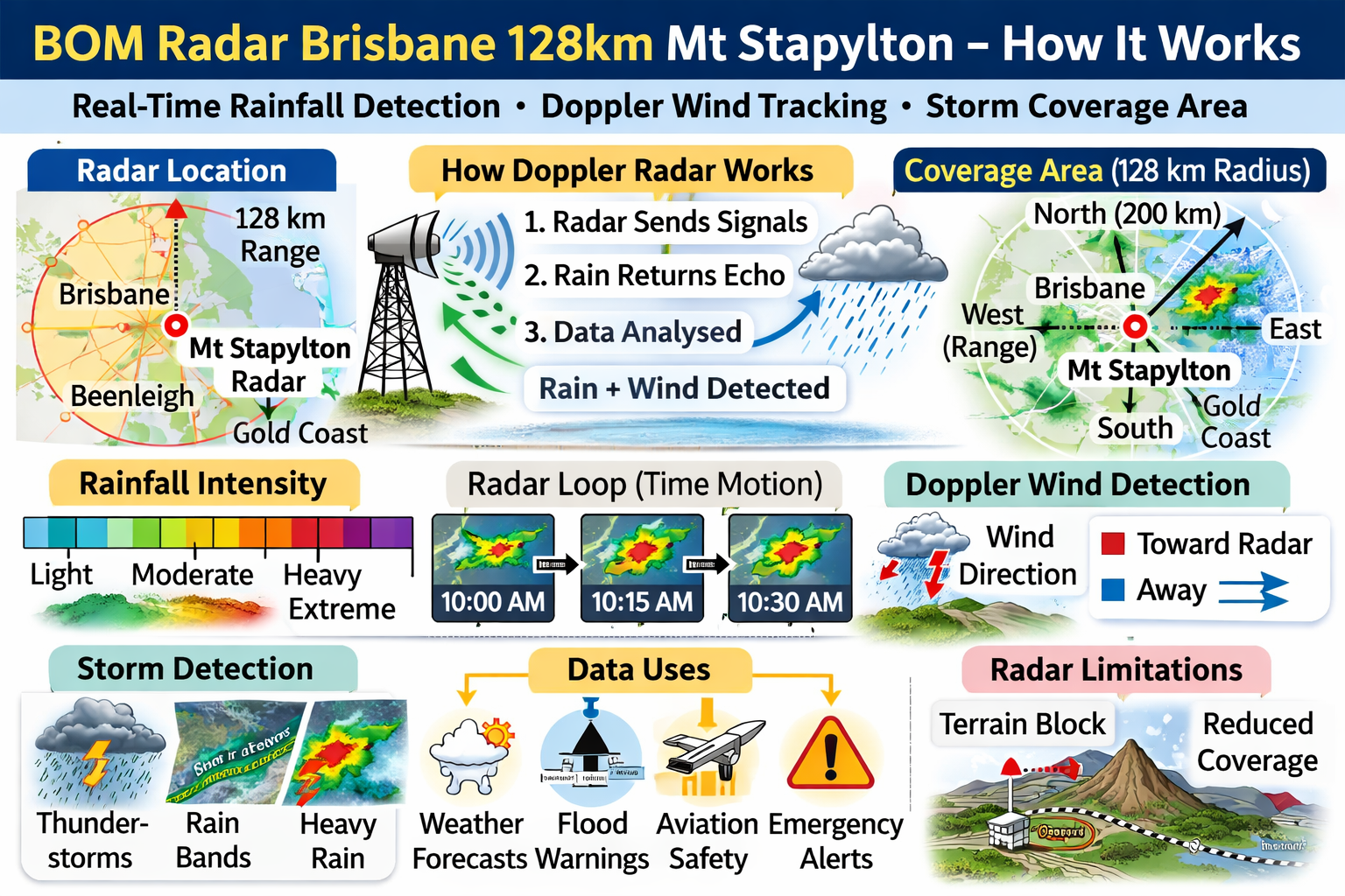
Using Doppler technology, this radar detects not only the intensity of precipitation but also the movement of raindrops, allowing meteorologists to infer wind patterns and storm motion. This capability is especially valuable for identifying convective weather systems, thunderstorms, and potential severe weather scenarios long before they reach populated areas.
The 128km designation refers to the radar’s primary operational range, meaning it provides high‑resolution data for precipitation and atmospheric motion within roughly 128 kilometres of the Mt Stapylton site. The radar also feeds into broader composite views with longer range radars for extended coverage across Queensland.
How the 128km Radar Works
Doppler Radar Technology
The Mt Stapylton radar uses Doppler radar technology, which sends out microwave pulses into the atmosphere. When these pulses encounter precipitation particles — such as rain, hail, or snow — a portion of the energy is reflected back to the radar receiver. By analysing the reflected signals, meteorologists can determine:
-
Rainfall intensity and distribution, showing areas of light, moderate, or heavy precipitation
-
Storm structure and movement, including tracking cells and fronts
-
Wind motion, including how raindrops are moving toward or away from the radar
The Doppler effect enables the radar not only to see how much rain is falling but also to infer wind speeds and directions within storm systems. This is crucial for understanding storm evolution and issuing severe weather warnings.
Radar Coverage and Signal Limits
While the radar’s main operational radius is 128 kilometres for detailed observation, its coverage can extend further under certain conditions. At higher altitudes, where radar beams rise above surface terrain, the system can detect precipitation echoes beyond this primary range. However, rough terrain such as the Great Dividing Range to the west and Lamington Plateau to the south can partially block the radar’s low‑level view in those directions.
This terrain effect means the radar’s ability to detect weak rainfall from low clouds may be reduced toward certain sectors, while larger rain systems and storms are still reliably detected across much of the region.
Radar Coverage Area
Geographic Reach
The Mt Stapylton radar has a broad and varied coverage pattern:
-
To the north, it can detect rain echoes up to about 200 kilometres toward Tin Can Bay.
-
To the east and south‑east, its effective coverage remains strong for rain systems moving toward the Pacific Ocean.
-
Inland to the west and north‑west, the radar extends irregularly across Queensland’s inland towns and agricultural zones, though coverage quality diminishes with distance and terrain.
Because the radar beams travel upward as they extend outward, the height above ground level increases with range, allowing meteorologists to detect storm cells at higher altitudes even when low‑level echoes may be obscured. This ensures a comprehensive view of storm developments, especially for convective or tropical systems that grow vertically.
Types of Radar Outputs
The BOM radar provides a variety of radar products that help interpret current and past weather conditions:
Rainfall Accumulations
Radar data are presented in different time windows:
-
5‑minute rainfall shows very recent precipitation intensity
-
1‑hour rainfall indicates hourly accumulations from recent storms
-
Since 9 am rainfall totals display rainfall since the beginning of the local rain day
-
24‑hour rainfall gives a full daily accumulation picture
These varying timeframes help both forecasters and the public understand rainfall trends, from rapid storm bursts to longer‑lasting rain events.
Doppler Wind Fields
The radar also displays Doppler wind data, which reveals atmospheric motion relative to the radar site. This is useful for identifying gust fronts, convergent wind patterns, or rotating storm structures — all of which can be early indicators of severe weather.
By analysing these wind patterns, meteorologists can better understand the dynamics within storm cells and improve short‑term weather predictions.
Role of the Radar in Weather Forecasting
Severe Weather Detection
The Mt Stapylton radar plays a central role in monitoring severe weather conditions across southeastern Queensland. During storm season — typically in the summer months — the radar helps detect and track:
-
Thunderstorms and storm fronts
-
Heavy rainfall and potential flooding events
-
Cyclonic influences from coastal or ocean systems
-
Rapid convective developments
Because radar data can show real‑time changes in precipitation and storm motion, meteorologists use it to issue timely warnings for severe weather, flash flooding, or thunderstorm activity long before these events impact populated areas.
Supporting Forecast Models
Radar observations also feed into weather forecast models, helping refine predictions on storm evolution, rainfall forecasts, and wind dynamics. By comparing radar data against model outputs, forecasters can adjust their predictions based on observed changes in real time.
This improves accuracy for daily weather forecasts and longer‑term outlooks, especially when combined with satellite data, weather stations, and upper‑air observations.
How to Read the BOM Radar Display
For users new to radar imagery, interpreting the radar display can be highly informative:
Colour Shading and Intensity
Radar maps typically use colour gradients to show rainfall intensity — lighter colours for low rainfall and darker shades for heavier rain. This allows users to visually identify storm centres and heavy rain bands quickly.
Movement and Trends
Animated radar loops show how rain systems move across the region over time. Watching these loops helps identify storm direction and speed, which is crucial for planning immediate responses.
Doppler Velocity Indicators
Doppler wind data use different shading to indicate motion toward or away from the radar. This helps isolate wind patterns within storm cells that could suggest areas of strong gusts or rotational features.
Understanding these elements enhances the practical use of radar data for both weather planning and real‑time decision making during dynamic weather events.
Strengths and Limitations of the Radar
Strengths
-
Continuous real‑time monitoring of rainfall over southeastern Queensland
-
Wide coverage across metropolitan, coastal, and inland regions
-
Doppler capabilities provide both rain and wind motion data
-
Supports severe weather detection and forecast refinement
These strengths make the Mt Stapylton radar a key asset for weather monitoring and public safety, particularly in regions prone to thunderstorms and intense rainfall.
Limitations
No radar system is perfect, and the Mt Stapylton radar has known limitations:
-
Terrain interference from the Great Dividing Range and Lamington Plateau can block low‑level echoes in certain directions.
-
Range limitations mean that very distant low‑level precipitation may be less accurately detected.
-
Radar signals can also pick up non‑meteorological echoes, such as stationary objects or sea clutter during strong winds, which can sometimes appear as false precipitation.
Understanding these limitations helps users interpret radar imagery more accurately by factoring in geographic and atmospheric context.
Interactions with Other Radars
Though the Mt Stapylton radar is the primary weather radar for the Brisbane region, it is supported by other radar assets:
-
The Brisbane (Marburg) radar was upgraded to dual‑polarised Doppler technology as a secondary system, providing complementary coverage when Mt Stapylton undergoes maintenance or outages.
-
Temporary radars — such as at Brisbane Airport — may also provide additional data during maintenance periods.
This network redundancy ensures continuous monitoring even when one radar is offline, helping maintain forecast continuity and public safety.
Educational and Local Uses
Beyond meteorological forecasting, the Mt Stapylton radar data is widely used by:
-
Local councils and emergency services for flood preparedness and response plans
-
Researchers studying atmospheric processes, storm development, and rainfall distribution
-
Educators and students learning about weather systems and atmospheric science
-
Weather enthusiasts tracking local storm events in real time
Radar data thus has broad applications beyond just official forecasting, helping inform decision making across community and scientific domains.
Bom Radar Brisbane 128km Mt Stapylton (FAQs)
1. What does “128km radar” mean?
It refers to the radar’s effective high‑resolution observation range, providing detailed data within approximately 128 kilometres of the radar site.
2. Where is the BOM radar at Brisbane located?
The 128km radar is positioned on an isolated hill near Beenleigh, southeast of Brisbane.
3. What type of radar technology does it use?
The radar uses Doppler S‑band technology, which detects both rain intensity and wind motion.
4. Can the radar detect winds?
Yes, Doppler radar can infer wind motion within storm systems by analysing how precipitation echoes shift in frequency.
5. Does terrain affect radar coverage?
Yes, nearby mountain ranges can reduce low‑level radar visibility in some directions.
6. Are there backup radars?
Yes, secondary radars like Marburg provide additional coverage when needed.
7. How often is radar data updated?
Radar loops are updated continuously in near real time, providing frequent rainfall and Doppler wind images.
Conclusion
In conclusion, the BOM radar Brisbane 128km Mt Stapylton is one of the most important weather observation tools in southeastern Queensland, providing critical real‑time data on rainfall and atmospheric motion. Its Doppler capabilities allow meteorologists to see both precipitation intensity and wind movement, supporting accurate forecast models and severe weather warnings.
The system’s strengths make it invaluable for emergency services, researchers, weather planners, and local residents who depend on reliable weather information. While terrain can affect coverage in some directions, the radar’s strategic location and integration with other network tools ensure broad operational effectiveness. For those who live, work, or travel in the region, understanding how the Mt Stapylton radar works enhances weather preparedness, situational awareness, and safety planning.